The water in the shipping channel subsides, a lock vortex forms and ships are torn from their guard posts. It isn't an isolated problem - it also happens at the lock of Terneuzen. But what causes these incidents? And how can we avoid them?
The Western Scheldt is located at the centre of the JNM area: it is one of the busiest waterways where inland and seagoing navigation constantly cross paths. Moreover, there are no speed limits, which means that ships pass by branching waterways at high speed.
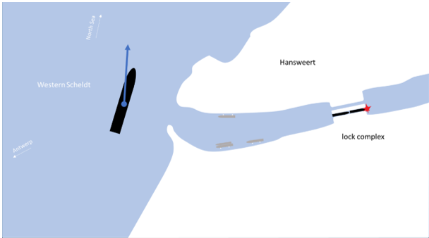
The lock of Hansweert, a crucial junction for inland navigation between the Western Scheldt and the Rhine delta, handles some 45,000 ships annually. Due to the proximity of the lock to the waterway, ships in the outer harbour are strongly influenced by the water movements of passing seagoing vessels.
© Dick Heijboer - TU Delft
The combination of lock activities and the tide makes the situation complex:
- If a ship passes by while the lock is open, the water level can drop so much that the ship is pulled out of the lock chamber. This carries a high risk of injury to those on board, as well as damage to the ship and the lock.
- The tide causes slack in the mooring lines of berthed ships. Especially at low tide, passing ships can cause such a large difference in height that the mooring lines break. As a result, some berths remain underutilised, while elsewhere in the Scheldt region there is a shortage of berths.
Over 1,000 ships, 2 conclusions
TU Delft student Dick Heijboer investigated how these incidents could be predicted. To do so, he placed sensors at various locations in the outer harbour. These collected data for seven weeks: the movement of the water, the tide, differences in height, etc. During that period, 1,281 oversized ships (longer than 210 metres, deeper than 10 metres, or both) passed by.
Heijboer's most important finding: the critical factor is the drop in the water level. A drop of 12 centimetres creates a critical situation, and most incidents occur at a drop of 15 to 25 centimetres.
What causes this drop? Heijboer examined the full impact of passing ships. Three factors proved decisive:
- Speed: 93% of the ships travelled faster than 10 knots.
- Distance: 84% passed within 600 metres of the outer harbour.
- Dimensions: the length and width of a ship both play a role.

© Dick Heijboer - TU Delft
Although the dimensions of ships – a stable factor – are expected to increase in the coming years, speed and distance have a greater influence. The faster and closer a ship passes by the outer harbour, the greater the difference in water level and the higher the risk of incidents.
Specific measures for fewer incidents
There are two ways to reduce the number of incidents:
- Address the cause: limit the drop in the water level to a maximum of 12 centimetres.
- Reduce the risk: increase the resilience of the outer harbour of Hansweert.
There are various options for both strategies. To limit the drop in water level, ships must sail farther from the outer harbour, sail more slowly, or both. Heijboer calculated that, depending on the distance, a speed of 21.5, 15.5 or 9 knots is sufficient:
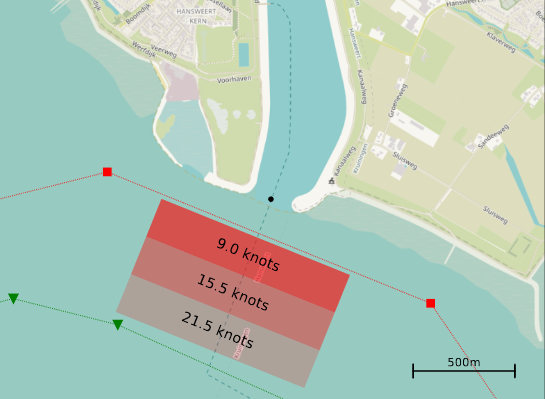
© Dick Heijboer - TU Delft
A calculation tool can help the pilots by, for example, determining the safe distance and speed per ship, depending on factors such as the draft of a ship and the average depth of the waterway and outer harbour. Ideally, that information would be integrated into electronic maps, so that pilots can react immediately.
Measures in the outer harbour itself can also limit the risk. By imposing a maximum mooring width and providing floating bollards and warning signs, we can minimise the slack on the mooring lines. Furthermore, coordinating lock planning more closely with shipping traffic can help prevent dangerous situations. In some cases, it may be better to only open the lock once a ship has passed by.
Beyond the outer harbour of Hansweert
In order to effectively put this knowledge into practice, pilots must be aware of the importance of the calculation tool. That is why the Joint Nautical Management will focus on providing information about its impact on inland navigation and raising awareness among seagoing navigation in the coming years.
Hansweert is not the only location in the JNM area facing this challenge. In 2025, we will build on Dick Heijboer's research with monitoring in Terneuzen (western and eastern outer harbour), Walsoorden and the Borssele Sea Jetty. This will allow us to come together and take further steps towards safe and smooth shipping traffic in the Scheldt area.